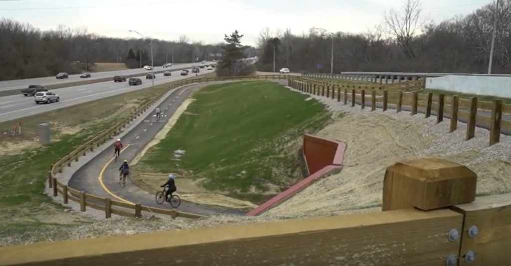
Central Ohio Greenways (COG) is a network of over 230 miles of trails that connects the Central Ohio region. COG trails offer a variety of opportunities for recreation and transportation, including biking, running, walking, scootering, and roller blading. COG trails also connect parks, neighborhoods, rivers, businesses, and cultural attractions, making them a great way to explore one of the nation’s greatest places to live, work, and play.
Established in 2015, the COG Board’s mission addresses the demand to expand the number of trail miles, increase access to trails, and encourage the use of trails for everyone. In 2018, COG developed a Regional Trail Vision to add more than 500 miles of trails to its existing 230-mile network across seven counties. These proposed miles extend existing trails, fill gaps in trail corridors, connect neighborhoods to job centers, and create a truly interconnected network serving as the backbone of the region’s active transportation and outdoor recreation network. As Central Ohio’s population is projected to reach 3.1 million by 2050, trails will play an increasingly critical role in providing transportation alternatives, access to nature, and a sense of communal connection.
The COG Board’s mission is supported by the work of various working groups and project steering committees that advance regional collaboration, trail marketing and promotion, and development, operations, and funding opportunities. The Board and associated committees are supported by diverse partners of local government staff, elected officials, advocacy groups, and planning firms who emphasize the positive impact of trails on quality of life, environmental vitality, and economic progress. Their work is available in the publicly available resources found below.
The Trails Alert and Closures section serves as a vital resource for individuals navigating trails within our region. It provides timely updates and notifications regarding closures along various trails, ensuring that pedestrians and cyclists are well-informed about any obstacles or restrictions that may impact their planned routes.
The Strategic Action Plan is meant to be a working document that provides direction to advance COG’s vision of creating a world-class network of trails easily accessible to every central Ohioan and its mission of increasing greenway trail mileage and usage for recreational and transportation needs.
The “Central Ohio Greenways Regional Vision Map” presents a comprehensive overview of the region’s existing trails and those envisioned for the future. This regionally supported vision guides the region’s trail and active transportation development efforts. Updates to the Vision are considered annually to ensure it reflects the most current understandings of feasibility, funding, and community desires.
The COG Board is actively pursuing the addition of around 500 miles of trails to the region’s network. This report assesses the desire among community, business, and philanthropic leaders, residents, and elected officials to fund and implement COG’s bold Regional Trail Vision. Despite a solid understanding of the feasibility challenges, including land acquisition, environmental permitting, limited funding, and cross-jurisdictional coordination needs, the community affirms the desire to build and fund the Regional Trail Vision.
Click Here to Download the Full Report.
The “Regional Trail Vision Prioritization” effort analyzed trail access and connectivity in Franklin County. It assessed the proposed trail segments’ potential to impact connectivity, public health, social equity, and economic development goals. This data-driven approach aids Central Ohio in prioritizing planning, funding, and construction efforts for trail segments and trail access infrastructure.
Click Here to View the Story Map.
A trail town embodies a community’s dedication to enhancing residents’ and visitors’ quality of life and economic prosperity by promoting trails and welcoming trail users. These communities typically have a well-connected trail network, supportive businesses, and a vibrant community atmosphere that embraces its trails as a defining aspect. This framework lays the essential groundwork for a successful Trail Town designation program. The framework analyzed existing conditions within four sponsoring communities to understand how a trail town program would best function in Central Ohio. This framework guides COG’s efforts to identify resources to launch and sustain a Trail Town program.
Click Here to Download the Full Framework.
This document is intended to supplement and build upon the 2022 Central Ohio Trail Town Framework by considering the unique needs of the urban communities along the trails. The purpose of this work and the Trail Town effort is to leverage the strength of the COG network to encourage active transportation, quality of life improvements, tourism, and economic development in trail communities.
The Central Ohio Greenways Trail Count Report examines trail usage across various greenways from 2014 to 2017.
Click Here to view the Trail Usage Summary.
The Trail Counter Pilot Project Report offers insights into MORPC’s pilot initiative, which introduced Eco Counter equipment to gather non-motorized traffic data on two Central Ohio Greenways. The report details the Eco Counter equipment, essential maintenance, installation guidelines, and associated costs encompassing equipment acquisition, upkeep, and setup. The results of this pilot project support MORPC’s recommendation to deploy Eco Counter equipment throughout the region to support a robust Trail and Active Transportation Count Program.
Click Here to Download the Full Report.
A partnership between Experience Columbus and the Mid-Ohio Regional Planning Commission created the Columbus Outdoor Trail Pass. This program encourages residents and visitors to explore various Central Ohio destinations by utilizing Central Ohio Greenways and local trails. Participants are incentivized by being automatically entered into local gift card drawings whenever they check in at a destination with their pass. For details on this program and how to enroll, the Outdoor Trails Pass Resource Page serves as a valuable source. Additionally, the page features two maps outlining the pass’s curated itineraries. These thoughtfully crafted routes guide users on exciting adventures along the greenways, facilitating stops at various engaging destinations along the way.
Click Here to Access the Columbus Outdoor Trails Pass Resource Page.
Click Here to Access the Columbus Outdoor Trails Pass.
The “Economic Impact of Central Ohio Greenways” report underscores the substantial advantages the envisioned COG trail network would bestow upon Franklin County. The expansion of COG trail segments fuels economic growth, prompting job creation and a total of $350 million in returns from the initial $203 million capital investment for completing the Franklin County network. Trails promote a healthier, more active lifestyle, yielding an estimated $57 million in healthcare savings and heightened workplace efficiency among active users. By choosing trails for transportation instead of driving, a reduction in carbon emissions could result in potential savings surpassing $525,000 annually. The local expenditure by trail users injects $136 million into the economy annually, bolstering employment opportunities and local businesses. Moreover, the trails serve as custodians of natural areas within a 50-foot radius, yielding annual environmental benefits valued at $1.2 million. The completion of the COG Trail vision will amplify the economy, public health, environmental preservation, and overall community well-being within Franklin County.
Click Here to Download the Full Report.
Click Here to Download the Executive Summary.
The “Central Ohio Greenways Best Practices Report” presents successful regional trail models from seven comparable regions—Houston, Indianapolis, Louisville, Milwaukee, Minneapolis, St. Louis, and Tucson—to inspire the strategic action plan of Central Ohio Greenways (COG). Through interviews and comparative analysis, the report extracts innovative strategies, partnerships, and organizational structures that have contributed to these regions’ achievements. The findings guide COG in enhancing its greenway system, fostering collaboration, and ensuring sustainable growth of the COG program.
Click Here to Download the Full Report.
The “Central Ohio Greenways Trail Design Standards” offer preliminary guidance to assist communities in the early stages of shared-use path development. The guidelines highlight fundamental design requirements, aiding in identifying potential physical or geometric constraints that might impact path alignments.
Click Here to Download the Full Design Standards.

111 Liberty Street Suite 100
Columbus, Ohio 43215
Phone: (614) 228-2663
TTY: 1 (800) 750-0750
Terms of Use | Privacy Policy | Cookie Notice
© Copyright 2023 Mid-Ohio Regional Planning Commission


