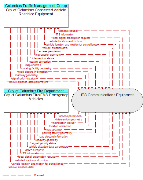
Interface: City of Columbus Fire/EMS Emergency Vehicles - City of Columbus Connected Vehicle Roadside Equipment
Architecture Flow Definitions
access permission (Planned ) Applicable ITS Standards
Information returned indicating whether permission for access is granted and instructions for proceeding.
access request (Planned ) Applicable ITS Standards
Request for access to an access–controlled transportation facility.
intersection geometry (Planned ) Applicable ITS Standards
The physical geometry of an intersection covering the location and width of each approaching lane, egress lane, and valid paths between approaches and egresses. This flow also defines the location of stop lines, cross walks, specific traffic law restrictions for the intersection (e.g., turning movement restrictions), and other elements that support calculation of a safe and legal vehicle path through the intersection.
intersection status (Planned ) Applicable ITS Standards
Current signal phase and timing information for all lanes at a signalized intersection. This flow identifies active lanes and lanes that are being stopped and specifies the length of time that the current state will persist for each lane. It also identifies signal priority and preemption status and pedestrian crossing status information where applicable.
ITS information (Planned )
Information exchanged by ITS systems or devices. This flow is a super–flow; it does not define specific content since it represents any information flow exchange between physical objects defined in ARC–IT. This information flow represents any of those information flows and inherits the data content and attributes defined in the more detailed information flows.
local signal preemption request (Planned ) Applicable ITS Standards
Direct control signal or message to a signalized intersection that results in preemption of the current control plan and grants right–of–way to the requesting vehicle.
location correction (Planned ) Applicable ITS Standards
Information provided to improve positional accuracy. These corrections allow a mobile GPS receiver, such as a GPS system in a connected vehicle, to achieve a
greater absolute positional accuracy, compensating for errors that exist in satellite positioning.
map updates (Planned ) Applicable ITS Standards
Map update which could include a new underlying static or real–time map or map layer(s) update.
parking facility geometry (Planned ) Applicable ITS Standards
Precise spatial description of a parking facility that locates each parking space and the ingress and egress routes that are used to travel to and from the spaces.
road closure information (Planned ) Applicable ITS Standards
Road closure information provided to passing vehicles. This flow provides information about the road closure with diversion information.
roadway geometry (Planned ) Applicable ITS Standards
The physical geometry of a road segment that specifies the location and width of each lane, including normal lanes as well as special lanes for pedestrians and bicycles, transit vehicles, and trains. This flow also may include the curvature, grade, and superelevation or banking of the road segment.
signal priority status (Planned ) Applicable ITS Standards
In response to a request for signal priority, this flow indicates the status of the priority or preemption request.
vehicle location and motion (Planned ) Applicable ITS Standards
Data describing the vehicle's position, heading, speed, acceleration, transmission, steering wheel angle, braking status, size information, and trajectory.
vehicle location and motion for surveillance (Planned ) Applicable ITS Standards
Data describing the vehicle's position, heading, speed, acceleration, transmission, steering wheel angle, braking status, size information, and trajectory. This flow represents monitoring of basic safety data ('vehicle location and motion') broadcast by passing connected vehicles for use in vehicle detection and traffic monitoring applications.
vehicle situation data (Planned ) Applicable ITS Standards
This flow represents vehicle snapshots that may be provided by the vehicle to support traffic and environmental conditions monitoring. Snapshots are collected by the vehicle for specific events (e.g., when a sensor exceeds a threshold) or periodically and reported based on control parameters when communications is available. Traffic–related data includes snapshots of measured speed and heading and events including starts and stops, speed changes, and other vehicle control events. Environmental data may include measured air temperature, exterior light status, wiper status, sun sensor status, rain sensor status, traction control status, anti–lock brake status, and other collected vehicle system status and sensor information. The collected data is reported along with the location, heading, and time that the data was collected.
vehicle situation data parameters (Planned ) Applicable ITS Standards
A request for vehicle situation data that includes parameters used to control the data that is reported and the flow of data reported by the vehicle. This flow identifies the type of data/snapshots that are requested and reporting parameters such as snapshot frequency, filtering criteria (data thresholds for reporting), and reporting interval.